By Reuters
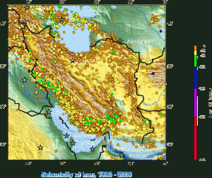
(Reuters) - Here is a timeline of some of the major earthquakes in Iran in the past four decades:
April 10, 1972 - An earthquake measuring 7.1 magnitude struck southern Iran around Ghir Karzin, killing 5,074 people.
September 16, 1978 - 15,000 people were killed by an earthquake measuring 7.8 magnitude, which leveled the eastern desert town of Tabas and many nearby villages.
June 11, 1981 - A quake measuring 6.9 magnitude destroyed the town of Golbaf, 800 km (500 miles) southeast of Tehran, killing about 3,000 people and injuring more than 800.
June 21, 1990 - 50,000 died and 100,000 were injured in the worst recorded disaster in Iran. The quake, magnitude 7.4, devastated the Caspian regions of Gilan and Zanjan. About 500,000 were made homeless.
May 10, 1997 - A quake measuring 7.3 magnitude killed 1,567 people in rural areas of eastern Iran near the Afghan border.
June 22, 2002 - An earthquake measuring 6.5 magnitude razed dozens of villages in north Iran's Qazvin province, killing 261.
December 26, 2003 - An earthquake measuring 6.6 magnitude devastated the city of Bam, 1,000 km (600 miles) southeast of Tehran, killing about 31,000 people.
February 22, 2005 - A strong earthquake of magnitude 6.4 in south-east Iran killed 612 people and injured more than 1,000 in and around the town of Zarand in Kerman province, about 700 km (440 miles) southeast of Tehran.
August 11, 2012 - Two strong quakes, measuring 6.4 magnitude and 6.3 respectively, killed at least 250 people and injured 2,000 near the city of Tabriz, East Azerbaijan province, a mountainous region that neighbors Azerbaijan and Armenia.
The Iran Project is not responsible for the content of quoted articles.

 QR code